Category:Amt Schlaubetal
Jump to navigation
Jump to search
| Object location | | View all coordinates using: OpenStreetMap |
|---|
collective municipality in Brandenburg state, Germany    | |||||
| Upload media | |||||
| Instance of |
| ||||
|---|---|---|---|---|---|
| Location | Oder-Spree District, Brandenburg, Germany | ||||
| Population |
| ||||
| official website | |||||
 | |||||
Subcategories
This category has the following 8 subcategories, out of 8 total.
G
N
R
S
Media in category "Amt Schlaubetal"
The following 4 files are in this category, out of 4 total.
-
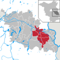 Amt Schlaubetal in LOS.png 299 × 299; 8 KB
-
-
 Wappen Amt Schlaubetal.png 800 × 897; 63 KB
-
 Wriezen - Bahnhof.jpg 4,096 × 3,072; 2.48 MB
_von_ODEG_31.7.2012.JPG)
